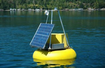
 NOAA, the National Oceanographic and Atmospheric Administration, part of the U. S. Department of Commerce, has deployed many distinctive, yellow data-gathering buoys globally. Six of them, all technically owned and managed by the University of Washington for NOAA, are located in Puget Sound. Five of those are in our West Sound region.
Here’s a list of the buoys along with their official identity numbers and general locations. They are part of what is called The ORCA Project. Here’s how NOAA describes it:
“The Oceanic Remote Chemical Analyzer (ORCA) is an autonomous moored profiling system providing real-time data streams of water and atmospheric conditions. It consists of a profiling underwater sensor package with a variety of chemical and optical sensors, and a surface-mounted weather station, solar power system, winch and custom computer and software package equipped with WIFI/cellular communication.
“Since its deployment in 2000, the ORCA system has provided a near-continual stream of high-resolution water quality data from locations in Puget Sound, Washington state. There are currently six such systems deployed around Puget Sound including Hood Canal.”
The five West Sound sites are:
- Buoy 46121, Carr Inlet between Maple Hollow and Green Point
- Buoy 46121, Twanoh, Hood Canal
- Buoy 46124, Hoodsport Hood Canal
- Buoy 46122, Dabob Bay
- Buoy 46125, Hansville
Sensing devices on these buoys, which stand about 9 feet tall from their water lines and extend about 8 feet under the water, are programmed to send nearly continuous data via satellite. That includes wind speed, wind gusts, wave height, air temperature, water temperature, water salinity, water oxygen saturation, tide height and barometric pressure.
You can go to NOAA’s National Data Buoy site at www.ndbc.noaa.gov and see the data record for dozens of reporting buoys and land-based recording sites, including, by buoy number, the sites listed above.
Here, in boring detail from the buoy website, are detailed descriptions of many of the data elements recorded.
| WDIR | Wind direction (the direction the wind is coming from in degrees clockwise from true N) during the same period used for WSPD. See Wind Averaging Methods. |
| WSPD | Wind speed (m/s) averaged over an eight-minute period for buoys and a two-minute period for land stations. Reported hourly. See Wind Averaging Methods. |
| GST | Peak 5 or 8 second gust speed (m/s) measured during the eight-minute or two-minute period. The five- or eight-second period can be determined by payload, see the Sensor Reporting, Sampling, and Accuracy section. |
| WVHT | Significant wave height (meters) is calculated as the average of the highest one-third of all of the wave heights during the 20-minute sampling period. See the Wave Measurements section. Note: Buoy WVHTs are combined seas whereas Ship WVHTs are observed wind wave heights. |
| DPD | Dominant wave period (seconds) is the period with the maximum wave energy. See the Wave Measurements section. |
| APD | Average wave period (seconds) of all waves during the 20-minute period. See the Wave Measurements section. |
| MWD | Mean wave direction corresponding to energy of the dominant period (DOMPD). The units are degrees from true North just like wind direction. See the Wave Measurements section. |
| PRES | Sea level pressure (hPa). For C-MAN sites and Great Lakes buoys, the recorded pressure is reduced to sea level using the method described in NWS Technical Procedures Bulletin 291(11/14/80). |
| PTDY | Pressure tendency is the direction (plus or minus) and the amount of pressure change (hPa) for a three-hour period ending at the time of observation. |
| ATMP | Air temperature (Celsius). For sensor heights on buoys, see Hull Descriptions. For sensor heights at C-MAN stations, see C-MAN Sensor Locations. |
| WTMP | Sea surface temperature (Celsius). For sensor depth, see Hull Description. |
| DEWP | Dewpoint temperature taken at the same height as the air temperature measurement. |
| VIS | Station visibility (statute miles). Note that buoy stations are limited to reports from 0 to 1.9 miles. |
| TCC | Total cloud cover (eighths). The total fraction of the sky covered by clouds of all types. |
| TIDE | The water level in feet above or below. See Mean Lower Low Water (MLLW). |
Swell Wave Data
| S1HT | Height of primary swell waves. Swell wave height is the vertical distance between any swell wave crest and the succeeding swell wave trough. |
| S1PD | Period of primary swell waves. Swell wave period is the time that it takes two successive swell wave crests to pass a fixed point. |
| S1DIR | True compass direction, in tens of degrees, from which primary swell waves are coming from. |
| S2HT | Height of the secondary swell waves. Swell wave height is the vertical distance between any swell wave crest and the succeeding swell wave trough. |
| S2PD | Period of secondary swell waves. Swell wave period is the time that it takes two successive swell wave crests to pass a fixed point. |
| S2DIR | True compass direction, in tens of degrees, from which secondary swell waves are coming from. |
Dial-A-Buoy
Additionally, it is possible to phone certain buoys to get up-to-the minute data. For example, there is a buoy located just off Tatoosh Island near the entrance to the Strait of Juan De Fuca. Its identifier is TTI W 1, and if one were to call 888-701-8992 and enter the identifier, a recording of that buoy’s recent wave and weather experience is played, and an option to also hear a weather forecast is offered.


